Thursday, April 12, 2012


Back in Phoenix, I began the day with a good jog through the campus of Arizona State University which was next door to the motel. The students look much calmer now that they have had their break, are back at work, and are recovering from liver damage.

Spent the day scoping out Scottsdale. Like so many places seen in Arizona and elsewhere, greatefforts have  been made to funkify the shopping areas in an Old West theme. And I must admit, it works. A free trolley carries the tourists (me included) around to reconnoiter the area and deliver them to the high end mall. I went for the air conditioning.

A friend and colleague from home is down here on a little break with friends and very graciously extended an invitation for dinner and a couch to this dusty and grizzly road warrior who is not at all, they learned, a Leonard Cohen doppelganger! I was most grateful for the charm and hospitality I was offered. It was nice to be able to engage in some good conversation, and enjoy some home cooking.

Headed towards the eastern edge of Arizona today, cruising along hwy 60 (passing through Globe again), 70 to Safford, 191 and just starting 78 which will lead me out of the state.


Huge open pit copper mines at Miami, Arizona.

Which requires some pretty big equipment.

The Bruiser is posing with a big truck which is sitting in the bed of an even bigger truck.


Arizona has some gorgeous and varied scenery. That said, it is a very big state and there are great expanses of flat and relatively featureless terrain between the viewpoints; case in point, Hwy 70 which was a long and tedious workout today. Most of the scrub has not been cleared or cleaned up for grazing or agriculture. The area looks poor, unkempt with miles of highway litter, discarded machinery and cars, and bombed out houses and buildings, that outlived their utility and were then abandoned and mistreated.

The Bruiser is always happy to head for the hills and his pilot maps out an appropriate course on secondary roads whenever there is an opportunity to do so. Roads become twisty and spirited through outcrops of rust-coloured and well weathered rock. At higher elevations it is cooler and the vegetation is more diverse. Even the weedy stuff at the roadside looks like a continuous floral arrangement of wild flowers and bristly grasses.


 Accommodation for the evening is wildcamping in the valley bottom of high desert grazing land, accessed by a dirt road off Hwy 78.


Prickly pear cactus are abundant and give the landscape a postcard kind of flavour, especially when the setting sun casts its orange glow.


Gusty winds that blew me around today have calmed. Somewhere in the distance a cow is bleating. 

Perhaps it is a bull. Hmmm….

Tuesday, April 10, 2012


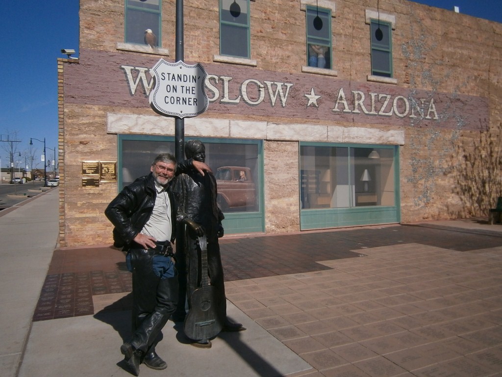
Although Winslow was named after some long forgotten dignitary, it was really made famous by a line from an old Eagles song of the early 70’s that has the lyric,
“Standin’ on the corner of Winslow, Arizona,
such a fine sight to see.
A girl, My Lord, in a flat bed Ford,
Is slowin’ down to take a look at me”.

Look in the window and you will see that there was an epilogue to the story.


Downtown Winslow is rather small, and there are not too many intersections. Although one in particular that recreated that scene from the song attracts more than a little bit of interest. A bronze statue of Don Henley (the songwriter of those famous lyrics) standing on the corner with his guitar and in the shadow of a big mural portraying the little vignette. A red flatbed Ford is parked just around the corner to complete the image.

For the purposes of The Bruiser Blog, it is important to note that a subsequent line in that song goes,
“You may lose, or you may win
But you will never be here again…”
… and I am ever mindful of that. 

We come this way but once. One has a personal responsibility to make it worthwhile.

I skirted the Evil I-40 by taking 99 through Reserve land to Leupp that was quite lovely in its wide-open splendor, and it delivered me to Flagstaff. The old town in Flagstaff is a treat for the eyes. Situated directly on the old Route 66 the buildings maintain that sense of nostalgia and funky architecture of another era that I quite like.

Of course one cannot possibly go through this region of northern Arizona without having the Sedona experience. Red canyon walls and fantastic wind sculpted rock forms which are backdrops to the emerald greenery of the pine forests and occasional cactus is spellbinding. Some sections were so impossibly beautiful that my heart was actually racing. I had to back up and run through some sections twice. Unfortunately the pictures I have fall quite short of capturing the scenes and can only serve as references and reminders.


Since I came through Sedona about 10 years ago, it has, unfortunately, grown up and become kind of city-like. That is regrettable, but inevitable. No Walmart yet, but it is simply a matter of time.

Again, to dodge the interstate I stayed on 89A and followed it south as far as I could. As luck would have it, this caused me to stumble upon Jerome. Wow! Billed as a mile high ghost town, this old copper mining town is not just perched up high in the hills, it is actually hanging off the steep face of the mountain. Switchback streets of the town are lined with interesting old buildings as well as newer touristy affairs. I have never seen anything like it! It must be experienced!

Needless to say, the twisty roads that snaked up one side of the 7000 ft mountain and down the other side made for some mighty fine riding!

But at some point it had to spill me out on Interstate 17 back to Phoenix. Truck traffic was light, but it was fast and gusty and quite exhausting.

I really hate interstate highways.

Monday, April 9, 2012


The Arizona Adventure

Getting out of Phoenix is a trick. The size of the place is impressive.
First stop was Casa Grande ruins, a rather large, mult-level structure build in the 1400’s by the Anza people. Most of the ancient dwellings in the Southwest are chiseled in the cliff faces, but this was build on the ground.


On a map, a circle tour on highways 15 and 86 to Tuscon looked interesting, but much of it was a long, straight and flat blow through the desert. However in certain places the vegetation was very diverse and lush and exotic and exquisite. Sequaro cactus stand like big, goofy gumbies with their limbs extending in crazy and sometimes comical poses. Within a couple of weeks many of the cactus species will be in full and spectacular bloom, but for now there are just tantalizing glimpses of the show.


On a couple of occasions I was stopped by a roadblock established by the U.S. Border Patrol looking for illegal immigrants. Luckily this grizzled Canadian alien was dismissed as being relatively harmless and allowed to proceed.

North of Tuscon on 77 near the town of Oracle one encounters the site of a very unique  and ambitious experiment conducted by the University of Arizona. ‘Biosphere 2’ is a self contained little ecosystem, sealed off from the Outside World. A number of humans can live together in it with a bunch of plants such that their CO2 is converted by plant photosynthesis to produce oxygen, wastes are used as fertilizer, water is recycled, etc. and the whole thing, in theory, can support itself. It is a model which might be used in colonies established on the moon or other remote and unearthly environments. It sort of works, but not very well. But it is very interesting. Not willing to pay for the big gate to go through the tour, nor willing to spend two hours doing it, I climbed up a hill on the perimeter to catch a shot of the exterior of the thing. I think I was correct in assuming that it was cheaper for the administration to print a sign referring to video surveillance than it was to actually install the system.

Incidently, and in case you were wondering, ‘Biosphere 1’ is a term reserved for Mother Earth who was the first to perfect this exquisitely balanced and complex symbiosis of interdependent life forms that proves very difficult to duplicate.

The run from Globe to Show Low (a town named for the outcome of a card game of the same name over a century ago) was the focal point for the next leg of the tour. Salt River cuts a 2000 foot deep canyon through stratified and colourful sedimentary rocks and it is a medium sized version of Grand Canyon. Numerous tight and twisty curves made it a thrilling as well as a superbly scenic ride.

Climbing out of the canyon at over 5000 feet the air chilled and the climatic zone changed from a smorgasbord of cactus and shrubs to dense pine forests with short, teal coloured grass in the under story. Rocks were the colour of stained iron, ranging from yellow to almost blood red. Some cactus flowers were in bloom with their wild and gaudy hues ranging from ultra violet to infra red. Nature’s pallet is loud and flamboyant in these Arizona hills.

Highway 60 comes out at the evil I-40. formerly the iconic Route 66 now paved over with four lanes and billboards, and currently the flight path of a steady stream of high velocity freight trucks. The blood returned to my hands when I eventually reached Winslow from my entry point at the old cowboy town of Holbrook. I was in need of a stiff drink when I finally came in for a landing. Windy side gusts are one thing, but when these buggers blow by at over 75 mi/h they create a turbulence that follows them for several hundred metres. The Bruiser is not a small machine, but we had to work hard to maintain a straight line with this endless parade of semis that outnumbered family sedans by a considerable margin.

Saturday, April 7, 2012


I knew this. The desert is very cold at night. Air and ground are still toasty at sunset and one is fooled into dressing lightly when crawling into the sleeping bag. That would be a mistake. At around 3:00 AM the cold wakes me up and I heap everything I have on top of me to hold the heat in. Then the sun comes up and quickly warms the tent and its contents to simmer in short order.

My road today led me south on 95 through Parker Dam which is a lush and green little haven in the desert, then east on 60 to Phoenix. This is a secondary road that more or less parallels the Interstate, and I aim to avoid Interstate highways if at all possible. Interstate highways are evil, built with the sole intention of getting the traveler to a destination as quickly and uneventfully as possible. As you may have gathered, that is certainly not the intention of Bruce and The Bruiser. Life is a journey not a destination, best lived on the secondary roads.
The Bruiser arrives in Arizona

Cactus appeared for the first time among the vegetation lining the roadside and became more densely scattered as The Bruiser and I probed the heart of Arizona. One variety in particular is sporting a glorious show of red flowers as spring seeps into the landscape.
Cactus flowers

Being the Easter weekend I thought ahead (imagine that!) and booked a motel in Tempe (a suburb of Phoenix immediately adjacent to Arizona State University) The loose plan is to do what is called a ‘shamrock tour’ of Arizona, touring the state by looping out from a centre point. Arizona has so much to offer that it is difficult to explore it effectively by driving in a straight line.

Streets and sidewalks in this neighbourhood are heavily populated by college students in various states of departure from sobriety, ever hopeful, I suppose, that all the book learnin’ that went on before spring break will still be stored in memory when they return where they left off.

Youth. I’m certainly glad I spent mine with greater diligence and responsibility.

Don't worry if you don't see a post from me for a couple of days. Rather than writing and posting every day perhaps I will consolidate this Arizona experience.

Happy Easter, Everybody! I hope the Easter Jackrabbit is good to you.

Friday, April 6, 2012


Up early to prowl the strangely quiet streets in search of a cup of coffee. Early morning in Vegas just has the aura of a hangover.

Decided to drive up the Strip one last time on the way out, and noticed several huge developments of hotel/casinos that were half constructed and stalled, the exposed iron beams rusting and the plywood bleached by the sun. Caught in the 2008 crash, I suppose, and the economy is still not healthy enough for the bankrollers to return to it.

Avarice, it would seem, exceeded tangibility. Intriguing but not inappropriate that that should happen here.

With the help of my invaluable GPS (God bless the Garmin people for this remarkable little device!)we found our way out of the sprawling city and headed south on 95. It was an uneventful and not particularly interesting ride with its long, straight, fast and largely featureless highway. Stopped for gas and internet here and there, the latter typically at a McDonald’s WiFi. All similar, but with some parochial differences that tickle me sometimes.


I have always thought so too. It is nice that they have finally come to terms with it!
It just seems hopeless, doesn't it?


Really? Is it necessary to put that on a sign? 


And while we're at it...


My old buddy Franco has spoken often of the little town of Laughlin about 150 km south of Vegas that was otherwise unknown to me. It was a little miniature of Las Vegas, with only the glitzy little strip in a town far too small to contain it. Laughlin seems like a clean, untroubled little adult playground On the opposite bank of the Colorado River is the much larger Boulder City, Arizona which I suppose offers the economic base and infrastructure support, and the bridge between them functions as an umbilical cord.

 The highways meander around in this southern tip of Nevada, criss-crossing into California and Arizona until I lost track of what state I was in. The most obvious clue was that the price of gas was $1.00/gallon more whenever I crossed into California.


  Famous Route 66 has been replaced or paved over by I-40, and brief sections of it either still exist in part or at least the heritage is acknowledged. (How many cities can you remember from the song? You get one point each).


At a parking lot in Lake Havasu I met a fellow who owned the bike parked next to mine, his being a brand new Victory and an absolute beauty it is. Rick bought it as a 65th birthday present to himself. We got carried into a long conversation about bikes, bucket lists, and various fates that fortunes that have taken us to our present states and circumstances. He is a cancer survivor with a zest for life, much energy and enthusiasm, and I think a new inspiration for taking his fine new machine on the road and doing some touring and seeking some adventures. I am not certain what is encouraging that particular idea, but I certainly support it. :)

Rick and his Victory, celebrating victory!

Rick dropped what he was doing and led me down the highway about 10 miles to a pull out off the highway which is a popular place to wild camp. His friend Max, a snowbird from Utah, camps out here in the winter time. She was parked there in her rig but feeling quite ill, so made only a brief appearance.

Rick, my friend, if you are reading this I thank you for your generous and inspirational spirit and wish you good health and great adventure. I would like to see some pictures of your ingenious bike trailer when you get it refabricated.

The moon is now full and huge here in the Arizona desert. A fresh and gusty wind flutters at my tent flaps.

Ahh….

Wednesday, April 4, 2012


It was a beautiful, clear, and initially warm night. The desert was still and silent. That has been said about this place—that there is a quietness to it and I will testify to that. Sounds get muffled somehow and it is tranquil to the point of being eery.  I fell asleep immediately. But not for long. The coyotes set up a chorus of chilling howls in the wee hours that brought me to full attention in a hurry. I don’t know how far away they were, but I’ll tell you I looked outside the tent to see if they had made off with some groceries off the bike. Their pups could be heard chiming in as well with their little yips and whines, just happy to be part of the pack. The babies were now part of the choir! Evidently they had dispatched some poor little rabbit and were having a primal ceremony. I have seen something similar at football games. In any case, all the other rabbits are on the alert, I'll wager, and those dogs won’t be sneaking up on another one right away.

On the road this morning I encountered a coyote who had mastered a unique hunting/gathering strategy. He stood in the middle of the road and cars invariably stopped to take pictures of him and occasionally throw him food.
"Hey Buddy, can you spare some change"?

"Hmmm.. whatcha got in there"?


  I stopped as well and he came over to sniff out the festering foodstuffs in my saddle bags.


Did some good riding and good dawdling today as I rode due south down 178 to take in all that Death Valley has to show. Another windy day that kept me on my toes anticipating strong side gusts in the exposed sections, which was pretty much most of it come to think of it. When following another bike I could see how we were leaning into the wind by several degrees just to keep a straight course. We must have looked like sailboats. It was warm, about 32C, but that was very easy to take. The record is 134F  which by my calculations is almost 57 C. There has been less than one inch of rain in the past 12 months. Spring is late, and little yellow flowers are popping out on what I believe are mesquite bushes.

That said, I was quite surprised to see a sprawling grove of palm trees, green grass and all sorts of plants at Furnace Creek. This is a classic oasis, where water burbles out of the ground in the middle of the desert. It is an odd phenomenon that has something to do with confined aquifers, but I won’t bore you with more geology today.
An Oasis, named after a car wash of the same name.

Water!!!

On to Badwater Basin which is a huge salt pan at 282 ft below sealevel. There is some water in it but it is quite undrinkable. Believe it or not there are little snails that thrive in the stuff. The mountains across the valley at this lowest point reach almost 12,000 ft high! This is truly a landscape of extremes!


Man in Black at The Badwater Basin


Finally turning east over the 5000 ft pass to Shoshone and found myself emerging from Death Valley alive and well. Quite an unforgettable place!

Some drunk went wild with a paintbrush and splattered the rocks and hills with an unlikely palette of colours. There are colourful and contorted sedimentary strata and evidence of volcanism as well. Lava flows and cinder cones are seen here and there, and these weather from black to red, orange, yellow, and sometimes blue/green.

And then… what the heck. Las Vegas is only an hour and a half away and The Bruiser has never been there before. So we cruised up and down The Strip a couple of times, and people waved at us and cheered. Evidently my blog has an impressive readership!


The Bruiser cruises The Strip!


Oh but it is a garish place! As much as it is bright and lively and flashy and colourful, it is seamy and excessive beyond measure. Little wonder so much of the planet despises the western world! 
But, it had to be seen. And such a contrast from the stillness I awoke to this morning!


Hot, tired and dusty it was just too difficult to keep going that late in the day with the task of finding a campsite beyond the city. Coincidently my home for the night is called the “Oasis”, which is fitting… and not. It is situated right in the Old Vegas to the north of The Strip and a block from Fremont which is the old strip, but renovated to now include a huge digital screen canopy over the street that lights up with a loud video production every half hour. Dinner was a gross hotdog and beer. Joining the throng of middle class America I walked it from one end to the other, taking in the shops and casinos and bars with their blinking lights of all the primary colours and the antics of buskers and dancers and painters and magicians and people dressed up as cartoon characters.
Yes, you read that correctly.

I think I prefer sleeping with sagebrush and coyotes.


A little geology lesson, if I may.
This region is known as ‘basin and range’ topography. Millions of years ago the churning inferno in the mantle a thousand kilometers under us attempted to rip the continent into two pieces, but it had a tough time doing it so finally gave up and quit. That left a deep rift trending north-south sort of along the California/Nevada border and in fact further north as well. The surface expression of that failed rift is a number of deep, flat bottomed valleys with a series of mountain ranges between them. Death Valley is one of them, but it has several parallel neighbours. The upshot of this is that as you traverse the region in a west-east direction, you keep climbing up and over mountains and crossing wide, flat valleys, I am now in the fourth such valley. The summit of the mountain pass to the west is about 5000 ft. As I came down the eastern flank there were signs announcing 4000 ft, 3000 ft, 2000 ft… I felt like I was coming in for a landing! The last time I descended so far and so fast I was in a 747.

Tonight I am camped out in the desert at Stovepipe Wells and the elevation is about sealevel.
The Bruiser arrives at Death Valley


Joshua trees dot the landscape in the less arid regions outside the Death Valley reserve.


The temperature was a comfortable 25 C for much of the day, dropping to about 18C at the summits and about 30C  when I stopped for the day.

Nice placenames!

If you look over the edge you will see the bottom of Death Valley, 5000 ft below


The big lesson I have learned here is to fill the gas tank and the water bottles at every opportunity. I was counting on a fill up at Tondo but the station had no gas. The next one was at Panamint Springs 50 miles away.
 “And between here and there there ain’t nothin’!” offered a helpful local. And he was quite right.
Miles and miles of nothin' but miles and miles.

When I did stop for gas there it was about $1.50/gal more than the normal price. Quite exorbitant, I thought. But after I did some arithmetic if figured it is still a few cents less than it was in North Vancouver when I left!

Often I would encounter a realty sign announcing a property for sale at a location far out in the absolute bugger-alls. Houses or trailers were perched on an unshaded slope like toaster ovens on a shelf.  Now, I do understand the motive of the vendor (somewhat more than I do the property owners who are staying put) but have to wonder how the realtors make a living here.

I would say it is a buyers’ market.


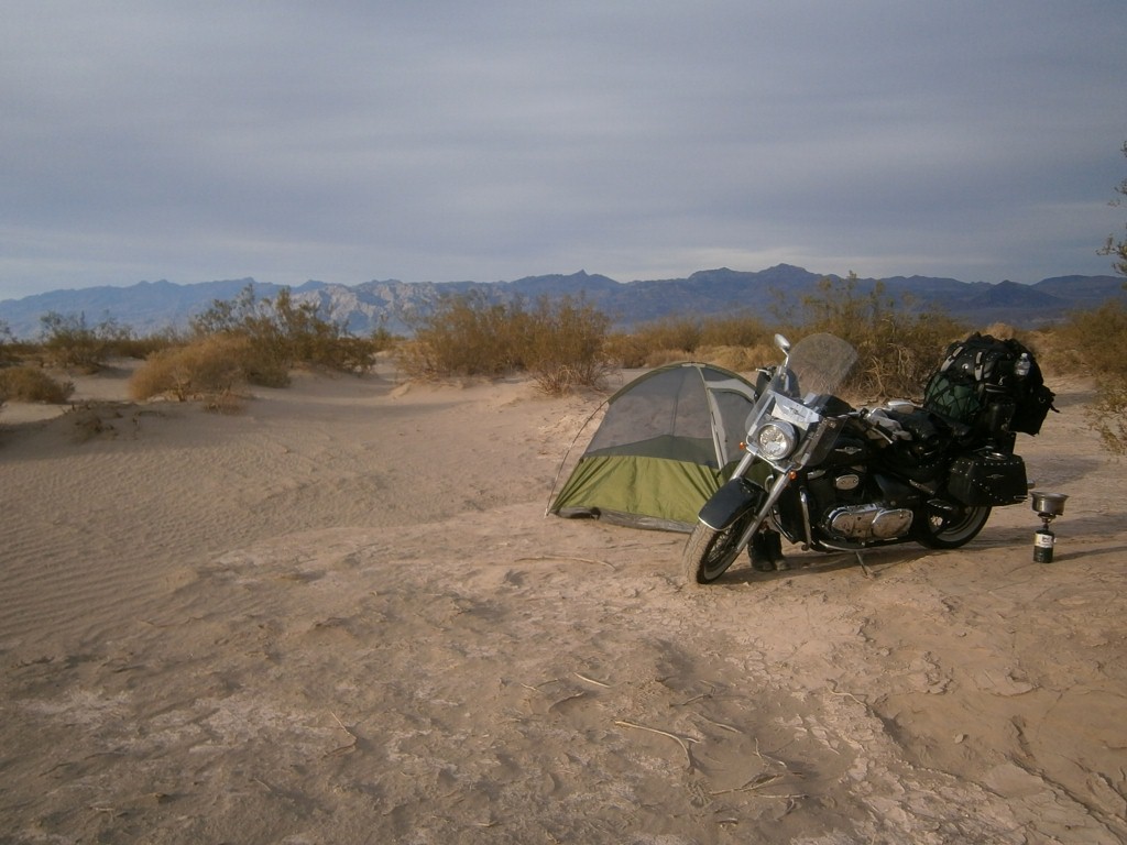
My little camp in the desert.

Exquisite!


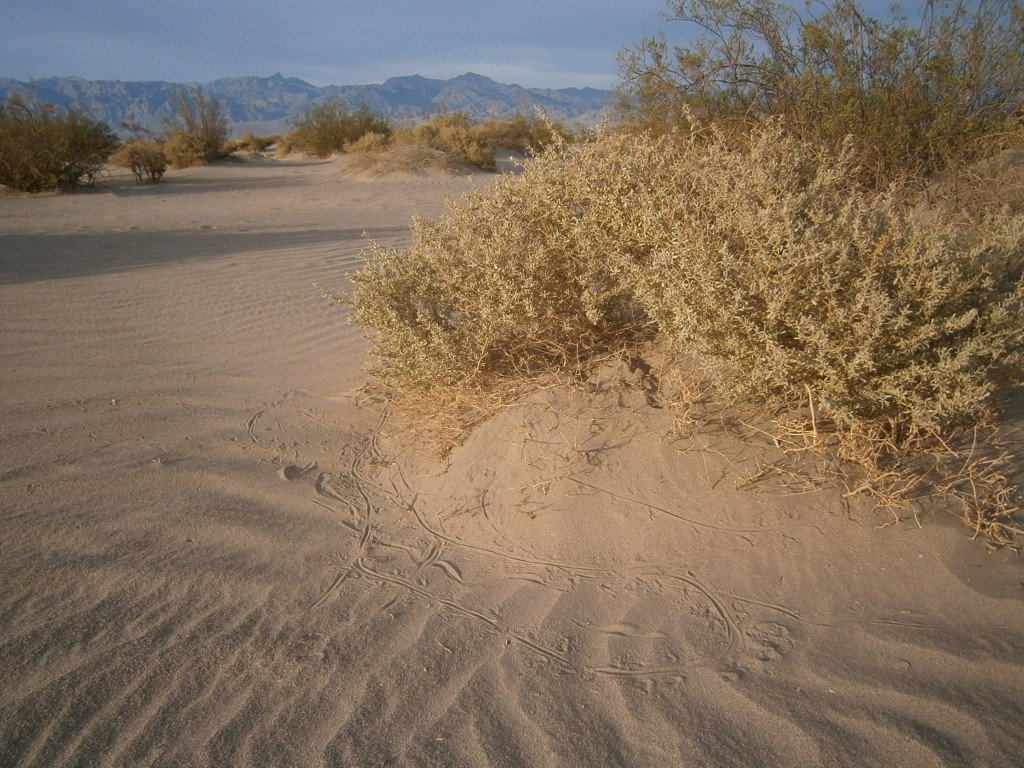
Notice the little lizard tracks in the sand at the edge of the brush.


At the time of this posting I have found my way out of Death Valley and am in metro Pahrump. Seriously.
Internet has been rather scarce for me lately.

More later!


Tuesday, April 3, 2012

All that lovely but oh so damp sea air has to go somewhere when it cools down at night, and in the morning everything was as wet as if it had rained. And it was a chilly sleep.

In order to keep the laptop, camera and ipod charged when I am on the road and far away from wall outlets, I rigged up an inverter which is wired directly into the battery and is on a cord long enough to run back into my bags. I hooked it all up this morning, but without the bike running it killed my battery. So I enlisted the help of a young teacher I befriended last evening and got him to push the bike to jump start it. And off we went.

Speaking of teachers down here, I read in the San Francisco paper how the local superintendent is stripping teacher seniority clauses, laying off teachers thought to be less effective, and hiring other teachers on “special assignment” to work with students outside regular schedules in order to boost achievement. Interesting.

Today’s theme is “variation”. I was astounded at the profound environmental transitions between locations very short distances apart.

The first 100 km was the continuation of the coastal route on Hwy 1 from Carmel to Morro Bay. It is truly one of the nicest roads and certainly the most satisfying motorcycle route I have ever seen.

A gaggle of tourists gawking over  a railing is always a good indication of something interesting, so we pulled over to check it out. Hundred of elephant seals were lounging on the sandy beach to sleep, scratch and catch some rays. According to the signage this is their favourite spot and March/April is their time. Must be spring break for them too.

As I returned to the parking lot a dozen bikes piloted by a grey haired gang of n’er do-wells were just pulling in. I chatted with one fellow with BC  plates who hales from Vernon, snowbirds at Palm Desert, and rides with his geriatric biker gang while he is here. He gave me some advice about the Death Valley route that I am aiming for shortly, so I was grateful for that.

Time to stock up on some groceries at Morro Bay. Washed the salt off The Bruiser and restored his chrome to its former glory, then turned inland on Hwy 41 and then 58. The coastal air, dunes and grasses were quickly replaced by rolling hills and pastures, liberally sprinkled with big, gnarly oak trees and ambivalent cattle. I rounded a corner, quite literally, and it abruptly changed to sagebrush similar to our Cariboo Country.  A short distance later it became a tabletop flat field of grass where the only trees in sight were clustered around family farms thinly scattered all the way out to the horizon.
Tumbleweed strained out of the wind by a fence

The road roller coastered then climbed up and over the small coastal range, offering thrilling twists and turns that I could enjoy with full spirit and without the fear of flying off into space as with the coastal highway. When one is in a groove it is like skiing, cutting swooping turns in soft and billowy snow. There will be a full treatise on the mechanics and skill sets of riding at a later time, but this was great fun.
Descending the coastal range. Great Valley seen in the distance

On the other side of that range lay the vast interior valley of California. Flat and featureless, it grew nothing but sparse grass that didn’t look capable of crops or grazing livestock. Quite a number of wellhead oil pumps were scattered around, most rusted and abandoned as the little pocket of oil somewhere beneath them were eventually depleted. Kind of a microcosm of things to come.


My route took me to Bakersfield, which considers itself the 'produce section' of the California supermarket. And indeed, farmland and orchards of fruit and nut trees abound. But a tourist hub it ain’t. I motored through it as quickly as I could. ‘Nuff said.

Imagine my surprise when just east of this rather uninspiring area, Hwy 178 led me through a very pretty little canyon cleft through the hills called the Kern River. 
Geological Michelin Men. Termed 'spheroidal weathering' for the geologically inclined

Weathered rocks on the canyon walls resembled little Michelin Men sculptures and the river spilled over numerous little rapids and watered a lush greenery on its banks.


Sunset comes around 7:30 but it was getting dark in the canyon before 6. I was headed for Isabella Lake another half hour away, but just happened upon what could only be a gift from the Wildcamping gods. Once a small walk-in campground, this little site beside the river was redesignated as a picnic area, and then for some reason was closed altogether. The parking lot had weeds growing out of the pavement so it had been in disuse for some time. The Bruiser squeezed quite nicely past the gate and the place was ours. It is a lovely spot and, happily, completely untouched by vandals. It seems like the picnic tables were all replaced by nice metal ones just before it was decommissioned. Most considerate, I thought.
Can you spot Waldo's tent?

So The Bruiser and I settled in, made some dinner, set up camp in a secluded little niche  and got comfortable. I went down to the babbling brook, dropped my gear and had what turned out to be a very bracing bath. I didn’t know they had glaciers down here! Wasn’t it more likely that this river was fed by the warm waters of Death Valley just to the east? Well, no, actually, Death Valley doesn’t have any water.
Let’s say that I am… refreshed.
Brrrrrr.....

Monday, April 2, 2012

Sunny and breezy all day.
Picked up my trail heading south on Hwy 1, following the coast and enjoying the eye popping scenery. Wouldn’t it be wonderful to be like one of those wall-eyed lizards that could keep one eye on the road and the other one bugged off scanning the scenery? They do look kind of goofy, though, and only another wall-eyed lizard would ever consider taking you out for dinner and drinks.

Somewhere near Salinas… (I’ve always wanted to be able to say that)... I stopped for lunch. It was in Monterey, actually. Another one of those tourist meccas that I am making a point of visiting.


 Snacked at a pretty spot on the shore just on the edge of Cannery Row and watched the seagulls dance with the pounding surf.


Took a little walk along Cannery Row just to see if my legs still work. It is a busy, kitchy, and colourful place, that occasionally gives tribute to the Steinbeck novel which made it famous.


I was looking forward to cruising the 17 Mile Drive, a fabulously scenic bit of shoreline with the Pebble Beach golf course at its southern end. I have driven and bicycled it a few times, once with The Mikoman sitting in a little milk crate fastened to the back of the bike.  The bad news was that motorcycles are now prohibited from the Drive! I suppose some irresponsible sportbike yahoos tore up and down the twisty road so the local administration decided this was a good way to put an end to it. I personally don’t see the justice in it, but the fellow at the gate was in no position to do anything but recite the policy.

Did a quick run through the funky and narrow streets of Carmel on the way through, then smacked my lips as I headed for Big Sur. This is a run that I have anticipated for many years, and I was not disappointed!
I was advised to gas up before getting started as the services along the way take advantage of their position as being the only show in town and double their prices. Literally. So I did, and they were right.


It is an excellent bikers’ highway. Apart from being very easy on the eyes, it is as curvaceous as a Vegas chorus line. Lots of sharp, linked and well engineered turns on a good surface. I had some fun. I will admit that the abrupt cliff edge and a 1000 ft  drop was a bit disconcerting and it certainly compromised the spirit of the ride from time to time.

My progress was slowed by my compulsion to stop and take pictures at every outlook. And there were many. I am running out of superlatives to describe the beauty of the landscapes I am encountering. I promise I will not rant any more about the surf… except for this: the monster waves I have seen and raved about so far were pipsqueaks compared to what I saw today. These were walls of water that I imagined tsunami must look like. That wicked storm to the north of us has really stirred up some action and it is an amazing sight. I did manage to capture some video of waves exploding on the rocky shore and tossing spray up the height of an apartment building, but I think the file is too big to load on this blog.

So many pictures I didn’t take! Wildflowers of every colour form a carpet over the rocks and occasional dunes, punctuated by spears of pampas grass. Sandy little coves appear, many with streams that slice through their beaches like miniature canyons.

My home for the night is a campground near Lucia, a bit more than half way down this section of highway. This is the first time I have set up my camping gear, so I will need to hone my routine for set up, cooking, and stowage. Sunset was a colourful backdrop to my nest in the eucalyptus grove. Big waves are slamming into the rocks below me and the air has the fragrance of the trees, the seaspray, and campfire smoke.