Saturday, May 5, 2012


The slow leak in my air mattress is getting bigger and my bones are being lowered to the ground progressively earlier each morning. It is far more effective than any alarm clock.

On our way to Moab we stopped at Monticello visitor centre for an internet and geographic orientation. Nearby there were more pueblo ruins that had to be checked out, and then we headed into the hills to see :Newspaper Rock". There is a less circuitous route to it, I learned later, that would have avoided having to climb up to the snowline, although the view from there was quite stunning.
Newspaper Rock. Actually, there is a guy sitting behind me with a mass of tattoos that look like this.

Newspaper Rock is a slap of darkened sandstone that The Ancients have used as a notice board, message board for the gods, or perhaps just a graffiti wall. Perhaps it is nothing more than doodles and messages no more profound than “Hopi is a corn head”. Really smart people have so far been unable to decode it all.  Although I will say that one character looks for all the world like Bart Simpson.
Tell me that doesn't look like Bart.

Moab is the place for the outdoorsy folks to be and be seen. What an adventure Mecca for the hikers, bikers, kayakers, rock climbers… you name it. My destination for the day was Arches National Monument, and this turned out to be quite the adventure.

The rock sculptures are nothing short of spectacular! I belived that Monument Valley would be the place to witness that, but the landscape here far surpasses anything I have ever seen. Around every corner was an eye popping sight that required a photo stop. At one of these I met a couple from France, Philippe and Catherine, who are driving around in a motorhome they rented from San Francisco. In spite of our language challenges, we became fast friends and met again at the trail head for a hike to Delicate Arch.
Wow!! What else can I say?

That 5 km hike is now on the top five of the most scenic and exotic hiking experiences of my life. Petroglyphs were exposed at the beginning of the trail just to add a cultural element to a magnificent stroll. We walked up and over sandstone bedrock to an elevation that afforded a view of the valley and surrounding cliff faces. Again the rock colours were what I would have to term simply 'unrealistic'. Rocks just don’t come in those flavours. A natural sidewalk angled us up the face of a rock wall, atop of which was a small arch. Begging a photo op we scrambled up to it to pose in front, only to see the big arch directly behind it. Images like that render one speechless.
That's cool, but look behind you, Boy!


Campgrounds were full, so it was necessary to be resourceful once again. We agreed to meet at a particular spot on a dirt access road just before sunset. My little camp was set up and I beginning to write this blog while the sun lit up the mini-Ayers Rock behind me and the big full moon hung like a party balloon over it. Life could not be finer.
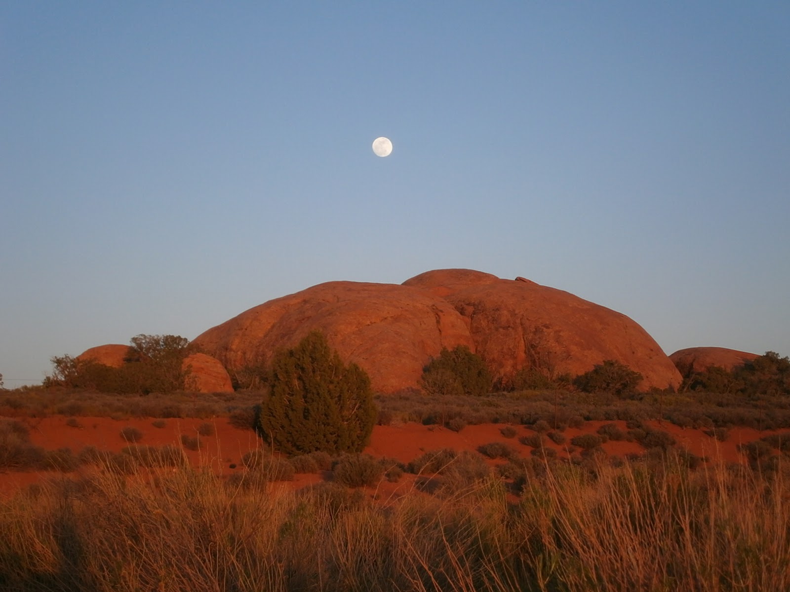
What a beautiful place this might have been to spend the night.

My friends soon came bouncing along the road to join me, followed by Mr. Ranger who reckoned something was suspicious about a big RV heading off into the sunset on a dirt access road. As indeed there was. Anyway, he shut us down and I was instructed to dismantle my camp and skedaddle. Rats.
But dismantle I did, and with haste as it was getting dark in a hurry. Driving out of the park the gargoylian rock masses against the moonlit backdrop presented a much different view than on the way in and I regret that I was in no position to make a photo stop.
Mr. Ranger did give some directions for a road outside the park alongside of which one can park and camp gratis. In practice, however, those instructions were inadequate and I have no idea what we has getting at. Even a day later and after conversations with the locals, it made no sense.

Roaring up the highway in the dark, however, and with no clear destination in mind was unsatisfying. Finally we found a parking lot for a saloon/restaurant right beside the highway that fit the bill. Philippe and Catherine invited me to take the overhead bunk in their spacious rig and I was happy to accept their generous offer.

Over a few beer and exchanges in our fractured English and French we had a pretty good chat. Coincidently, they live a short distance from the area in Burgundy where cousin Betty and friends Lisa and Dorothy and I will be cruising in our canal boat at the end of June.

Every day is an adventure, eh what!

Friday, May 4, 2012


Greeted the day to realize that the breakfast larder was nearly empty. Luckily there was still some coffee left, but I fueled up with a tortilla, cheese, and tomato sprinkled with“Smack Yo Momma” hot pepper spice.

The Bruiser had another oil transfusion, this time with a new filter. (Otherwise it’s kind of like having a bath and putting on old underwear. But I digress). The point is we have covered two oil changes worth of mileage so far. I'm starting to look at the rear tire that was brand new when we left  and it is showing considerable wear.

We wound our way along hwy 160 to the town of Kayenta where I picked up some groceries (I’d really prefer to have oatmeal for breakfast) and of course I posted my daily blog and read my emails which I appreciate so much.

Even in the modern era, Navajos still like to ambush people. Every time I climbed off the bike someone wanted a handout or wanted me to buy something. Natives have control over much of the land in this region and they like to set up a fee station whenever there is something we might like to see.

Four Corners is a case in point. It is nothing more than a surveyed point on the ground common to Utah, Colorado, Arizona and New Mexico. Five bucks to see it. I’m sorry. They don’t know who they are dealing with. I’m a pensioner and I’ve got attitude.

Big deal.

Kayenta is the starting point to the marvelous Monument Valley, a collection of  red mesas and rock spires that is an iconic symbol of the Southwest and a place I have been hankering to visit for a long time. Geologically, they are erosional remnants. The earth doesn’t actually make these pillars of rock, it whittles everything else away and these are what are left. Rather like the last piece of cake on your plate.

The main road, hwy 191, goes reasonably close to these things, but with the perpetual haze in the air they always look small and vague. To get closer... well, let’s just say the Navajos run tours to bring you up close and personal, or else you could drive into a little village which is situated right in the thick of it, but it is a fee area.  (For my view on that sort of thing, see above). But I spotted a dirt road that headed directly up to a collection of rock spires and I thought I would get clever and check it out. After about 100 metres of dirt the surface abruptly turned to deep sand and after a bit of a Watusi we nearly dumped. I’m not actually sure how we managed to keep upright but very grateful we didn't.
Mexican Hat.
 
The Bruiser arrives in Monument Valley
Church Rock is the exposed throat of an ancient volcano that has otherwise weathered completely away. The magma that filled that vent is more resistant to erosion than the rock it intruded.

In any case, I filled my eyes with geology and magnificent landscapes and took a few hundred pictures to show you all later. At the town of Mexican Hat I turned west on Hwy 261. After a few miles along a flat plain I could see the road was heading straight into the wall of a 1200 foot cliff.  Where is that going, I sez to myself.
We're going up that? How?

Unbelievably, the road went straight up the face of the bloody thing! Pavement ends and the road narrows and threads its way up a 10% grade with nearly 180 degree switchbacks. As some of you may know I have developed what I will call a deep respect for heights. Hugging the rock face as tightly as I could so that I was unable to look down—WAY down—we crawled our way up in first gear. This was possibly the most hair raising, sphincter tightening  drive I have ever done. I didn’t know they could make roads like that!
Here is a side view of a neighbouring plateau that resembles the one we climbed.
Looking down when pausing to breathe again. Note the switchback road below us

The road flattened out at the top of the plateau and resumed to highway speed limit. After a short while I encountered a cowboy on horseback driving a herd of cattle down the middle of the road, apparently in the direction of that hairpin descent to hell!  I considered waiting around to see how it went, but the truth is I would have been unable to watch anyway so I set a course instead for Natural Arches National Monument.

We arrived late in the afternoon and had time enough to drive the looping road to the various overlooks. Unfortunately the only campground was small and full. Rocky and The Bruiser have the capacity to be resourceful in such situations. I remembered an access road to a hiking area just a few miles back, so we backtracked to it. Being mindful of the sign that warns that the red clay road is impassible when wet, and casting a prayerful eye to the rain gods overhead, in we went and in short order found a great little spot to set up for the night. The late day sun lights up these brick red hills that surround me and the temperature drops immediately as it dips over the hills. Almost 8000 feet here. 

Well, I must go dress for bed now!

Thursday, May 3, 2012


And yes it was a chilly night. I had to wear all my clothes in my sleeping bag. But there you go—life at 8000 feet in the spring. Latitude doesn’t matter much.

But never mind that. Today is the day I saw Mesa Verde, the most elaborate and sophisticated village (or collection of villages) of the ancient Puebloeans. I learned that their modern descendents don’t like the term Anasazi since it is a Navajo term and they are not partial to Navajos. Mesa Verde is perched at about 7000 feet or so atop a big mesa, or flat-topped hill.
Mesa Verde is at the top of this thing. It kind of begs the question doesn't it?

There's a  happy boy!
The cliff dwellings are the certainly the most famous housing development in the area, but it should be said that the surface dwelling villages were well established for about 500 years (roughly 700-1200 AD) and they moved to the cliff condos for only 100 years (roughly 1200-1300 AD). In the end, the local resources of wood, game, fertile soil, and living space were depleted with a 25 year drought being the final straw. The story is the same with the Gila dwellings I saw in southern New Mexico.
Earlier dwelling (pre-cliff). The round pits are ceremonial 'kivas'. Remains of some residences are in the background.
The stone boxes in the foreground surround flat rock slabs which were used for grinding corn.

The surface dwellers constructed an amazing reservoir and water collection system that served them well for centuries. After the easy hunting and gathering was exhausted, and well before the first Walmart came to the area, they became pretty good farmers. Perhaps as many as 5000 souls lived here in its glory days with hundred of dwellings discovered in the vicinity.
Ancient reservoir

Cliff dwelling architecture is something out of Disney World or a fantasy movie set. Simply an amazing thing to behold. It doesn’t appear to me that there were any city planners involved in the construction, more likely it was like constructing a Lego village fitting homes and storage areas and ceremonial gathering places as they went and where there was room to build them. The end result is both whimsical and ingenious. Some of the structures had as many as four stories as log joists were placed on top of the wall of building stones. We could see where doors were added, filled in or moved and rooms added on at later times. It seems like spousal requests for home renovations have been with us for a very long time.

The big round pits in the foreground are called Kivas, and these were likely ceremonial in nature. Like the living spaces, they would have had log beam roofs and ladders for access. A fireplace is built into the wall with an interesting air damping system to control the burn and to provide ventilation for what must have been an asphyxiating atmosphere. Evidently this was before the WCB made regulations for acceptable living and working conditions.
A kiva sans roof. Horizontal beams were perched on the stone supports around the edges. Fire pit in the centre, air draft in the wall behind it. The upright stone slab was to control the draft.

One of these kivas was restored to show motorcycling tourists what it might have been like inside. Luckily they held off on firing up the smoke pit.
Inside a reconstructed kiva

Mid afternoon is always when the day gets interesting for me as I start to scramble to find some accommodation. Oftentimes that requires driving some distance in a bit of a hurry before it gets too late and darkness approaches.  With a fresh tank of gas, a cup of restorative java in hand and a map in front of me, it was time to plot a course. The only government park and campground that I could find within driving distance was about 50 miles west at Hovenweep National Monument.

Never heard of it.

After twenty-five miles of deserted and gradually deteriorating farm road that I had to coax my GPS to acknowledge as a legitimate byway, I was beginning to wonder where the heck I was going. But here it is. Campers and RV’s appeared out of the ether, set up in a small but nicely developed (albeit a bit Spartan) campground on the edge of a rock canyon.

Signs directed me to a trail to “ruins”. OK. Let’s do that. So I put The Bruiser down for a nap at our selected site and trundled off to see what I could see.

Well, well! About a dozen ancient structures lined the edge of the canyon, and the farther I walked, the more that came into view. With no one around to smack me, I stepped over the rope next to a sign that read “Do Not Enter This Area” and I entered the area. (I hope my kids or former students aren’t reading this). Self-guided tours are often the best kind. There were towers, both round and rectangular, homes built into cliff faces, and free standing multi-roomed barracks. Apart from cleaning up the rubble from partial collapse, they were left pretty much the way they were found. Very cool. As the sun was getting low and golden, the setting was mystical in a National Geographic kind of way.
Lookin' out my backdoor! How many structures can you count?

Selecting a few pictures to show you from the plethora of photos I have amassed is a sizable challenge, yet it leaves so many remarkable images unseen. So I will have to sit down with each of you at the end of this big adventure and show you all of the several thousand that, regretfully, I have been unable to post here. Together with expanded commentary of course. So be patient. More are coming.

This place is at high elevation and a considerable distance from the nearest streetlight, so the stars should put on quite a display this evening. Coyotes are tuning up as the birds have all signed off for the day.

Tonight I am sleeping with the spirits of the ancients who dwelled just over yonder.

I rather hope they are sleeping too.

Wednesday, May 2, 2012


Los Alamos is the place where The Bomb was invented. Street banners announce that this city “..Is Where Discoveries are Made”. True enough. The Bruiser and I went looking for the Los Alamos National Laboratory where nuclear energy  research continues and it wasn’t hard to find. The labs cover an area the size of a small university. One of the streets that transects it is called “Bikini Atoll Boulevard”. Seriously.
The Los Alamos National Lab. Actually, this is their parkade. But that is where the really smart guys park their cars.

Hwy 4 from Los Alamos to Jemez Springs is delightful. Twisty curves, lovely scenery and little traffic makes for a winning combination.  A massive fire burned through these forests a couple of years ago, coming down to the road and properties. I imagine more than a few farm houses were lost. Bandelier Cliff Dwellings that we visited a dozen years ago are closed to the public likely due to the burn that must have hit it square on.
The burn. I'll bet those home owners were nervous.

The Bandelier cliff dwellings are dug out of beds of volcanic ash that constitute some of the layers within the stratigraphy of these rocks. Ash lithifies to form a rock called tuff that, although millions of years old, is only partially consolidated and would be easy to dig into. The tuff originated from monumental volcanic eruptions nearby and there is ample evidence of the violence that this area was witness to. Following an eruption the explosion crater often collapses to form a huge depression called a caldera (latin for ‘soup pot’ I think) Crater Lake in Oregon is one familiar example. Valle Caldera resulted from the collapse of the monster volcano that ejected all of the ash found in this area. The caldera is several miles in diameter, now grassy and peaceful and green and the elk graze blissfully within it.
Valle Caldera. This is the collapsed centre of a mother of a volcano. It blew 500 times the material that Mt St Helens did.

Another consequence of volcanism is geothermal activity. Yellowstone is a famous example of hot springs and geysers where groundwater heated from the hot rock deep underground from the dormant volcano finds its way to the surface. Jemez Springs is a town built around a hot spring heated by the cantankerous old smoker that blew this area to bits so long ago. And if one looks carefully, one is likely to find a non-commercial hot springs in a nice, secluded little areas in the nearby forest. One might even be disposed to soak and linger in such a thing and luxuriate in the serenity of that magical find.
Bliss!

I am frankly at a loss for words to adequately describe the stupendous beauty of the colourful rocks and sculpted landscape that erosion has chisled out of it. Rocks are so red they are maroon, but cameras can’t capture the scene and nothing digital can properly display the fantastic colours or the sensation of moving through it. If I stopped to take a picture of every vision that caused my jaw to drop and heart to pound, I would not have covered much distance at all today. As it was, state troopers stopped twice to ask if I was alright as I was propped up at the roadside trying to take a shot that said it all. (No sir. Just fine, sir. I’ll be moving along).
An inadequate image to illustrate the magnificence of this place.

All I can say is, just get in whatever vehicle you have and get yourself down here and you will see what I mean. I can’t just tell you.

Hwy 550 from Jemez to Aztec is a four laner, and once through the distracting scenery at the south end of it we were able to put some tarmac under the wheels. By late afternoon we crossed into Colorado, another first for me. (Airport lounges don’t count). It’s funny how the setting changes so abruptly when crossing a border. There is no reason for it really, apart from different strategies and policies for development and maintenance. But the hills and valleys and rocks and ground cover all become… different. Perhaps it is owing to the abundance of water here and the high elevation—between 7000-8000’—that there is rich pastureland and farms. But it is more than that. A place has an identity and a personality that is more than just its geography.

A coyote ran out in front of me and stopped as we were going full tilt.
Our eyes met.
He ran back.
Breathe!

The Bruiser and I are camped out at Mancos State Park just outside of Mesa Verde. It is not yet open for the season, but it suits my needs just fine. The seasons are going backwards as we go north and ascend the Colorado Plateau. In fact, on some high passes the deciduous have only just started to bud. And of course it will be bloody cold up here tonight! We have moved from mid summer to early spring.

Monday, April 30, 2012


Ooooo it was chilly one last night! Just 2C when I shivered over to my thermometer to check. MEC rates my stupid sleeping bag at -7C and they call it “North Face”. Ha! It wouldn’t survive the north face of some mound in Costa Rica! Perhaps I will wear my leathers to bed. During the day they are particularly good for sweltering.

Hwy 64 from Raton, heading SW in the direction of Taos. Passing through the little town of Cimarron around noon I took the advice of the proprietor of a little trinket gallery and went to the St James Hotel for their famous $5 lunch. Apple, cheese and a handful of nuts can only take a man so far. I had a big juicy burger and fries and loved it.

There is some history to this hotel. Built in the mid 1880’s right at the side of the Santa Fe Trail it was the place to go in these parts if you wanted a good meal, a game of poker, or a shot of whiskey and a cigar at the bar. No less than 26 men stopped bullets in that bar during its heyday. It now boasts a wonderful salad bar and the sweet potato fries were delicious.
St James Hotel, Cimarron NM. 50 years ago a guy could get shot here. Evidently the place has ghosts, too.

Cimarron Canyon restored this biker’s faith in good riding roads. I had to stop to first consult my recent treatise on ‘cornering’ because after the endless plains and sagebrush bugger-alls of Texas I had forgotten how to negotiate a corner. Sapphire streams gurgled through cool and magnificent rock canyons. Aspen and pine lined the curvaceous roadways, and Man and Machine were in their glory once again.
Rocks! Trees! Rivers! Winding roads! Aaahhh...!

A few weeks ago we found ourselves at nearly 300 feet below sealevel. Today we crossed a mountain pass at just shy of 10,000 feet. As the elevation went up, up, up, the temperature went down, down, down and it was necessary to stop and don some supplementary clothing. On the way down, it all came off again. Well, not all of it.
Look at those big honking dust devils!

Red River is a ski area just east of Taos with a hill and lift in the centre of town. Thematically the place could be described as “cowboy alpine” with some lederhosen with spurs tossed in for good measure.
Red River NM

Ski New Mexico. Note residual snow, April 30.


Schnitzel!? Them's fightin' words, pardner!

Taos has a flavour all to its own. All the buildings share the same style of round plastered adobe, whether it is a church, fire station, shop, or fast food restaurant, and I’ll admit that it is rather cool. Shoppers love this place although that is not really my thing and it was wasted on me. But I did enjoy walking around and drinking in the architecture just the same.
Somebody's house

Perhaps it was the elevation, maybe dehydration, a lack of sleep on the freezing ground last night, likely exhaustion from many continuous miles full on--but I hit the wall this afternoon. I was feeling a bit confused and it was a struggle to navigate a course out of town. I stopped at a cemetery to photograph particularly ornate and colourfully decorated plots but it triggered an unexpected emotional response and I felt the need to get myself grounded somehow. Several miles of twisty and scenic roadway did the trick and I was fascinated by the quirky little towns like Truchas where artisans hid themselves away to ply their crafts. But by the time I reached Espanola with the western sun cooking my face and no place to camp for another 50 miles, I reckoned it was time for a motel. Hot water, cold beer, a soft mattress… Priceless.

I’m done for the day.

PS Sorry, no correct responses about Bob Wills. The three piece snakeskin formal attire has been returned to the Methodist Church Yard Sale. Click here for the answer: http://www.youtube.com/watch?v=X37xnM3VYH0

After the sun set, things got interesting. There was a lot of action over at Dubya’s camp across the gully from us. Headlights from a whole fleet of vehicles came on and lit up the whole park, then a procession of black sedans and white trucks exited the park at high speed down the road to Amarillo. While all this was going, on a distant lightning storm that appeared to be hanging over Dubya’s compound (but was actually much farther away) lit up the sky in a really eerie way. It reminded me of something from “The X Files” or “Close Encounters of the Third Kind”. In my mind the plot line would go like this: an alien spacecraft descends and abducts Bush. The world is kind of ambivalent about that. So are the aliens. Then they change their minds and put him back. The End.
What do you think?
The George W. Bush camping compound

Another storm fired up on the western horizon in the wee hours. Great flashes of soundless light woke me up, and gradually the thunder started to rumble as the storm approached. Fearing a deluge I scramble to tie a tarp over my tent to enhance the water damage clause on my camping insurance and did a poor job. It was too small to do much good anyway, but the rain was light and brief and I came to see it as a test by the Texas Rain Gods. What it revealed is that I need to be better prepared for such a thing.

While I was fumbling with it the storm parked directly over my head and let loose with some simultaneous blasts of light and sound that were stupendous. One in particular was something I will never forget. We were hit by a burst of intense light together with a crackle and a blast that nearly knocked me over. It felt like a direct hit with a bomb that had no percussion. It made my ears ring and I nearly wet my pants.

I bid farewell to my camping neighbour who is facing some tribulations and big decisions in his life. He fell apart after his wife died and is struggling to find a foothold. Scott is a really decent guy and I wish him well. Good and bad fortune are not evenly distributed among us, it seems.

With the exception of one restricted region in the southwest, Texas has been very hospitable and friendly. I have changed my mind about it., That said, it is finally time to get myself out of it. 
The back of the "Welcome to Texas" sign.


Hwy 87 takes a NW diagonal from Amarillo all theway to Raton, New Mexico. Gently rolling hills and the odd curve made it more interesting than much of the riding we have done in Texas. My nemesis the wind kicked up again and threw me around soon after crossing into New Mexico. The temperature dropped and dark clouds and rain shadows appeared on the screen ahead of me. 

An approaching storm.

The Capulin volcano is a fairly recent (700 year) cinder cone.
When I though rain was imminent I pulled under the roof of an ancient and dilapidated service station at Capulin. Timing could not have been better. What a storm! Punishing rain became a thunderous hail storm with stones ½ inch diameter. When the show was over a half hour later the ground was thickly covered with hailstones, forcing me to wait for the slush to melt before I could put myself back on the road. Within 20 minutes the temperature rose from 7C back to 26C, the roads were dry and it was as if nothing had happened. Still wearing my winter gloves, sweater and rain gear I entered the visitor centre at Raton on an otherwise hot and summery day and tried to get my bearings.

No, that's not the Rio Grande. It is Hwy 87.


And as soon as the plow trucks come, I'll be on my way.

This is in the vicinity of an exposure of the Cretaceous- Tertiary (K-T) Boundary that was a motivating theme for this trip. (More blather was written about this on the March 15 blog). My destination for viewing this exposure was just over the New Mexico-Colorado border near Trinidad. Imagine my dumbfounded delight when the guide at the centre said, “oh, you’re looking for the iridium layer? You can find that in the park at the edge of town.” Not only is it well known in these parts, it is handily accessible as well. She even gave me a little printed map to show me the way.

I was very excited! Off we went, up a gravelly hill that The Bruiser handled bravely, and around a corner, and…..

Yes!!
And there it is, Folks!

The dust and pulverized rock that settled out of the atmosphere was primarily glass, melted from the asteroid impact. Over time it chemically altered to clay. When exposed to air and moisture it weathers to a white material. Fossils of dinosaurs and their neighbours are found in strata below this layer, but not in the younger strata above it. This indicates a mass extinction event. Life on earth changed as a result of it.

Truly, this is a thing with extraordinary significance to me. It was like visiting a shrine of some kind. What it represents in terms of a history-determining event is staggering, yet it appears as nothing more than a thin layer of clay. 

The asteroid was like a 10 km wide assassin’s bullet that changed the course of earth history.
Hmmm… there is a theme that has been explored before.

But that is the value of knowledge, I told my students. Erstwhile mundane and common things become imbued with significance, and it empowers us to see the world that we encounter as a limitless collection of deeply rich and meaningful things with connections to innumerable elements of history and current condition. Life is enriched. Learning is good.

Bummer about the dinosaurs, though.

Sunday, April 29, 2012


Opportunities like this come by so seldom that they ought not to be missed. We felt compelled to go to Magnum for the Rattlesnake Festival.

And indeed there were rattlesnakes

And things made out of rattlesnakes

And fleamarkets AND… I’ll be damned!
Corn dogs!!!!

Zigzagging west through Oklahoma we tried to find the most scenic roads. Alas, there were few hills and valleys, and the roads were rather straight, but the soil was blood red and the greenery is just so, well, green, that it was a treat for the eyes.
I don’t know what it is about this Red-Green colour combination that makes me think about duct tape.

Oklahoma was a lovely state and I regret that only 24 hours was spent on its lovely soil, but as we follow that western sun in the vague direction of home what should we encounter yet again but…


TEXAS!!

Texas has tendrils like an amoeba, and one of its pseudopods—refered to as The Panhandle—sticks up between Oklahoma and New Mexico. So we’re back.


Some interesting little towns appeared along the way. There must have been a real deal on red bricks at the turn of the century because the roads in several of these towns are paved with gazillions of them.
The Red Square, Texas style. Just in case there is a civil uprising and they need a place to gather for a barbeque.
Memphis? A couple of surprises here. I always thought it was in Tennessee. And really, I did expect something bigger.

Then there is the town of Turkey. Rather than putting people off with a silly name like Turkey, they flock to it. This weekend, as luck would have it, Turkey was celebrating the legacy of one of its sons, Bob Wills. Some of you may be scratching your heads about that, but here that is a famous name. Why, you will see at the bottom of the “Welcome to Turkey, Texas” sign a footnote that adds, “Home of Bob Wills”. I have a three piece rattlesnake leather Sunday goin’ to meetin’ suit for the first one who can tell me who Bob Wills is. No Googling allowed!

My driving destination for the afternoon was up the east side of Caprock Canyon. But like a doofus, I missed the turnoff at Silverton and blew by it by 20 miles before I realized. Now, I will tell you that one of the finer things about traveling alone is that you can make a stupid mistake like that, whack yourself upside the head for being so thick, and then never hear about it again.

Just shy of Amarillo Texas is a state park called Palo Duro that I set as my nightspot. Imagine my surprise when I found out that the place was over run with Secret Service agents and that camping was off limits for everyone this weekend. Seems that former president George Dubya Bush is having a little vacation over there and that’s that.

I am camped at the private campground just across the gulley and can see the security vehicles scurrying around as me and my new friend and camping neighbour, Scott are drinking beer and thinking about getting all liquored up and going over to say hi later. Scott pointed out that we would likely be shot and I suppose he has a point.